Prince William and Kate, the Duchess of Cambridge, walk hand in hand from Buckingham Palace.
The royal couple will spend a majority of their trip visiting the former British colony.
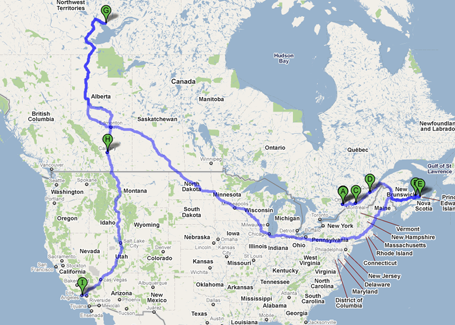
In what’s sure to be a whirlwind journey for the royal couple, more than 80% of their visit will be spent in America’s neighbor to the north. William and Catherine will begin in the Canadian capital on June 30, after which the breakneck journey will shuttle them from city to countryside, from warm coastal towns like Summerside, Prince Edward Island to the chillier Yellowknife in the Northwest Territories. All told, they’ll see eight Canadian cities in nine days, hustled around by the Royal Canadian Air Force.
(PHOTOS: The Wedding Day of William and Kate)
And the Canucks are more than thrilled to be hosting the newly-minted Duke and Duchess of Cambridge. Canadian Prime Minister Stephen Harper is touting the visit as “an opportunity for all Canadians to take pride in our traditions, history, and institutions.” After all, it’s Catherine’s first visit to the country – and to the continent as a whole – and officials will do everything in their power to ensure it’s not her last.
Click here for the full Google Maps trip
Then at the tail end of their journey, they’ll finally cross the border into the United States for a three-day visit to Los Angeles. British news outlets note that they’ll likely attend a BAFTA film event while in town – but in an unexpected twist for the star-centric city, the Brits will surely the most sought-after celebrities in Hollywood that day. When they’re finally wheels-down back in London they’ll have logged an exhausting 14,000 miles of travel.


